Reading time: 5 minutes
Google Maps is one of the most used tools by users who need to know how to get from one point to another, distances, street locations, traffic, among many other dates.
However, there are many other platforms that are beginning to integrate increasingly competitive features. For example, the possibility of being able to view maps or install them on any device without having to have an Internet connection.
These and many other features have increased competition and proliferated mapping applications. What are the best alternatives to Google Maps?
The most recommended alternatives to Google Maps at the moment
navmii
Navmii is one of the most complete platforms for map consultation and GPS function
- Includes a free speed camera detector
- Detect traffic conditions in real time
- You can use this service simultaneously with Google Street View

Bing
Bing Maps is also one of the advanced options and similar to Google Maps except with all the features that make it stand out. It allows the visualization of the images recorded by the traffic cameras.
In addition, it allows you to draw on the map, save and share points of interest, and view the terrain in 3D.
GPS co-pilot

In addition to having basic functions such as map download or GPS function, this service offers other functions. For example you can save your parked location and search for sites on Yelp and Wikipedia.
If the download of the map of a country is free, in case you want to download more maps of other countries it is necessary to pay a fee.

ottoman

Another option similar to Google Maps, for which you do not need an internet connection. With this application you will be able to use a brush that will show you the orientation, maintain the lights of your choice or upload satellite images from Bing maps or from OpenStreetMap information.
In addition, you can check the points of interest that have a long route, and include the number of sites in the local languages of the country in which you find, with their phonetic transcription.

Here we go

With this service you can download any map from the platform either from your smartphone or from your computer. This is the great advantage of Here We Go: you can use the GPS service offline.
The maps of the application are free and all of different recent routes depending on the chosen means of transport, as well as the cost of the trip or the level of gasoline required if you plan a route in check.

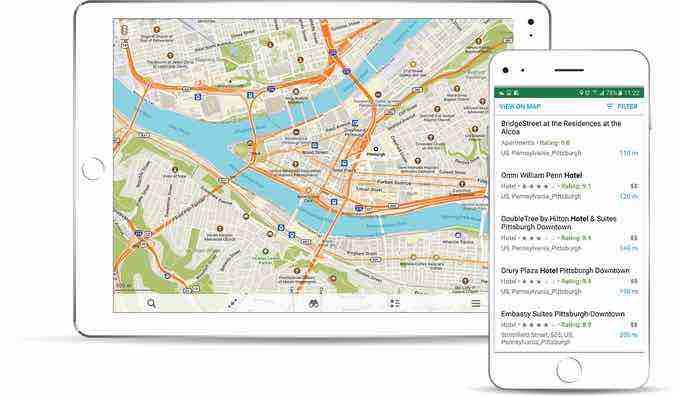
OpenStreetMap
This online tool is a project that has been created by thousands of volunteers from all over the world, who have been creating huge maps of their own data. All maps are free and open.
In them you can find detailed information on trails, streets, roads or services. You can access OpenStreetMap without registration and for free.
city mapper

For now, this application is limited to a few cities around the world, but it is an excellent alternative to be able to move freely in all of them.
- It offers minimaps with all the metro networks in the city
- Available routes adapted to the different means of transport from this city to the sea and, by bike, taxi or public transport
- Calculate the time at which you must leave to arrive at another exact time at your destination

arcane maps
An alternative to Google Maps that cares about the privacy of users. For this reason, no type of registration is necessary to make use of its services. Although it is in beta phase, it has many interesting features.
For example, it allows you to store your favorite places in personalized lists and offers traffic information or different points of interest.
Apple Map Connection
The service for Mac and iOS users is updated from time to time adding new features such as the possibility of locating bicycle stalls in the big cities of the world.
In addition, you can share the time it will take to get to a certain place with other users, and even plan a route with all the available schedules of the different means of transport.
Sygic GPS and Maps
This platform, similar to Google Maps, has recently been updated by integrating an augmented reality function. This way you don't need to follow the route on a map, but can follow directions from a smartphone camera preview.
In addition, the platform offers suggestions for finding parking, speeding warnings and even offers the possibility of integrating the screen into the windshield at night.
PRO 3D maps
This service is specially designed to offer specialized guides on trails, routes and paths. Thanks to the integrated 3D maps, you can visualize the type of terrain, mountains or trails of a given route. Very much in the style of the Google Earth service.
The app can be used offline and offers the ability to take a trip by storing coordinates and elevation data.
map factor
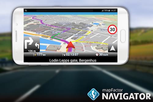
One of the outstanding features of this service is that the service is updated every month, this guarantees that the routes are 100% verified. With Mapfactor, you will receive notifications of stable speed traps and checkpoints.
It offers cross-border navigation, without having to switch between maps of different countries. You can orient the map to the north or to the direction of travel, and view the routes in day or night mode.

maps.me
Maps.me integrates all OpenStreetMap cartographic material into its platform. The great advantage of this service is that the maps can be stored offline. In addition, it hardly takes up space since the data is downloaded compressed.
It offers numerous information related to categories such as restaurants, leisure or hotels. It is ideal for when you travel and you do not have data on your smartphone, since it will allow you to get to any point without problems.

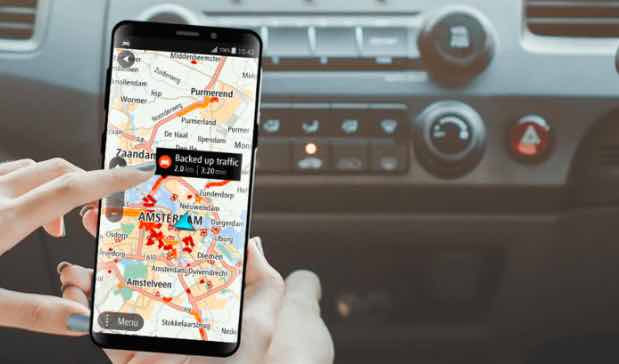
Waze

Waze can be a platform that includes more than Google Maps thanks to the new features it offers
- You can customize the instructions with your suggestions
- Allows you to include a custom icon of your own checkbox to display it on the navigation screen
- Issues alerts of mobile speed cameras, works or accidents
- Always opt for the shortest route and notify before any incident

tom tom go mobile
This alternative to Google Maps is one of the best known worldwide that incorporates the Tom Tom GPS in its version for mobile phones. The maps can even be stored on your computer and can be used without an Internet connection.
Maps are free and the app is constantly updated. In this way, it always offers the safest routes and the best alternatives.

What is the best option similar to Google Maps?
Due to the multitude of advanced features and its pleasant and safe design, Waze has become the platform that many users prefer to Google Maps. Its success is such that Google Maps itself has begun to integrate some of its functions.
Waze is a much more complete tool, which integrates all kinds of options to make the route safer, more comfortable and, above all, dynamic.
The platform allows you to grab your bike and include it to opt for different celebrations, monitor your speed, have a record of the routes you use frequently, use it if you ride a bike and allow it to integrate with Spotify.
So Google Maps is a useful option and with many possibilities, it still has a lot of work to do to keep up with the Waze platform.
